Gisborne, New Zealand
- For other uses of Gisborne see Gisborne (disambiguation).
Gisborne (Māori: Tūranga-nui-a-Kiwa, "The place where 'Kiwa' - of the Tākitimu waka - stood") is the name of the largest settlement within the Gisborne Region of northeastern New Zealand.
Gisborne is named after an early Colonial Secretary William Gisborne. The council is located in the City of Gisborne.
Contents |
Geography
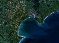
The city of Gisborne is located at the north end of Poverty Bay. The white cliff headland of Young Nick's Head at the other end of the bay is visible from the city. The cliffs can be seen in the left hand side of the sat photo. The Māori name for the cliffs is Te Kurī-a-Pāoa[1], meaning The Dog of Pāoa, as this was what it was originally said to look like.
This prominence was the first part of New Zealand sighted by the crew of Captain James Cook's ship Endeavour, and was named for the crew member who first saw it. A memorial to Cook stands on the foreshore, marking the point where he first stepped ashore in New Zealand on October 8, 1769.
On the right hand side of the sat photo at the other end of the bay, known as Poverty Bay, is Kaiti Hill. This hill overlooks the city and magnificent views can be obtained by driving or walking to the summit.
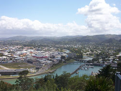
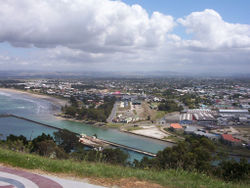
The city maintains a rural charm and is a popular holiday spot. Local industries include agriculture, horticulture, farming and forestry. Wine production is also valuable to the local economy. It is sometimes known as the City of Rivers as the centre of the city is the convergence of three different rivers.
Gisborne City has four main high (secondary) schools: Gisborne Boys' High, Gisborne Girls' High, Lytton High and Campion College. Campion College is a Catholic co-educational school.
The harbour was host to many ships in the past. A meat works was sited beside the harbour and meat and wool was shipped from here. Now the harbour is the home of many smaller fishing boats as well as ships loading logs for export.
Gisborne boasts being the first city in the world to greet the sun each day. Technically, however, this is only true for part of the year. Both Suva, Fiji, and Nukuʻalofa, Tonga, are closer to the International Date Line and therefore would seem more likely candidates for this title. Due to the Earth's tilt on its axis, however, Gisborne does overtake their claim as New Zealand summer days grow longer. In the longest days of summer, though, it again loses the title to the hillier suburbs of Dunedin in the South Island.
The city has the benefit of being very close to the white sand beaches of Waikanae and Midway. A short distance from the city is the surf beach of Wainui.
Two major annual events are the Dawn Raid Beach Day Out, which is an outdoor concert featuring many of the Dawn Raid Hip-hop stars held in January, and the Rhythm & Vines concert held every New Years' Eve which features a huge concert featuring well-known New Zealand and International bands performing in a vineyard.
Gisborne had three sister cities in the Sister Cities International Program, two are in the United Kingdom (one in Wales and Scotland), the third being Palm Desert, California in the US. The town of Gisborne 50 kilometres north-west of Melbourne, Australia is now also twinned with it.
Climate
The region is sheltered by high country to the west and has a dry, sunny climate with high sunshine hours.
| Climate data for Gisborne | |||||||||||||
|---|---|---|---|---|---|---|---|---|---|---|---|---|---|
| Month | Jan | Feb | Mar | Apr | May | Jun | Jul | Aug | Sep | Oct | Nov | Dec | Year |
| Average high °C (°F) | 24.9 (76.8) |
24.2 (75.6) |
22.6 (72.7) |
19.9 (67.8) |
17.1 (62.8) |
14.7 (58.5) |
14.1 (57.4) |
14.9 (58.8) |
16.8 (62.2) |
19.0 (66.2) |
21.3 (70.3) |
23.3 (73.9) |
19.5 (67.1) |
| Average low °C (°F) | 13.6 (56.5) |
13.6 (56.5) |
12.2 (54) |
9.6 (49.3) |
6.9 (44.4) |
5.3 (41.5) |
4.6 (40.3) |
5.4 (41.7) |
6.8 (44.2) |
8.6 (47.5) |
10.5 (50.9) |
12.3 (54.1) |
9.1 (48.4) |
| Precipitation mm (inches) | 54 (2.13) |
78 (3.07) |
99 (3.9) |
103 (4.06) |
97 (3.82) |
125 (4.92) |
119 (4.69) |
93 (3.66) |
101 (3.98) |
63 (2.48) |
65 (2.56) |
67 (2.64) |
1,050 (41.34) |
| Source: NIWA Climate Data[2] | |||||||||||||
The region has a yearly average of 2,200 sunshine hours. The annual rainfall varies from about 1000mm near the coast to over 2500mm in higher inland country[3]
Transport
State Highway 2 passes through Gisborne and Gisborne is the northern terminus of the Palmerston North - Gisborne Line railway, which opened in 1942. Passenger services were provided until 1988, when the Endeavour express was cancelled north of Napier. Today, the railway carries solely freight.
Suburbs of Gisborne
|
|
|
Gardens in and around Gisborne
Gisborne has its own botanical garden: Gisborne Botanical Gardens
In the surroundings are two arboreta:
- Eastwoodhill Arboretum at Ngatapa
- Hackfalls Arboretum at Tiniroto
Sport
- Gisborne's soccer team Gisborne City won the Chatham Cup in 1987 and has twice been runner-up. Its home ground is the Childers Road reserve.
- In rugby union Gisborne is home to the Poverty Bay team, who play in the Heartland Championship rugby competition.
- In cricket, Gisborne is part of the Northern Districts Cricket Association, and first-class matches are occasionally held at the Harry Barker reserve.
Famous residents
Sister cities
 Palm Desert, California, United States
 Nonoichi, Ishikawa, Japan
 Gisborne, Victoria, Australia[4]
References
- ↑ "Ngā waewae tapu – Māori exploration" - 20 May 2008 - Te Ara Encyclopedia of New Zealand
- ↑ "Climate Data". NIWA. http://www.niwascience.co.nz/edu/resources/climate/. Retrieved 25 February 2009.
- ↑ Gisborne Weather at gisbornenz.co.nz
- ↑ "Sister Cities". Gisborne District Council. http://www.gdc.govt.nz/council/sister+cities.htm. Retrieved 2008-11-25.